KL, Tokyo, and Grenoble.
The three cities I call home ❤
This post starts off sentimentally but it’s actually going to be a factual and technical one lol. This is how I express my love for these three places: I’m going to compare the sizes of these three cities and the experiences of my commute! YEASSSSS HOW EXCITING!!
When people ask me exactly how big Grenoble is and is it a town or a city or just a French rural countryside, I always have difficulty explaining it because although I know exactly how small big Grenoble is, I never really tried to grasp exactly how big Tokyo or KL are, and how they compare. In fact, to be honest, I’ve never looked closely at a Klang Valley map until a couple of years ago.
Note: The pic of Tokyo and the featured pics of KLCC and Grenoble are mine. Maps and Google Earth are from Google of course
Source: Wikipedia and personal experience
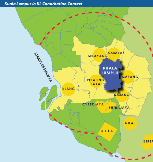
First, let’s take a look at the total surface area of each city. They are all zoomed in on Google maps at the 1 : 10km scale.
Kuala Lumpur (City): 243 km
Klang Valley (or Greater KL): 2,243.27 km2
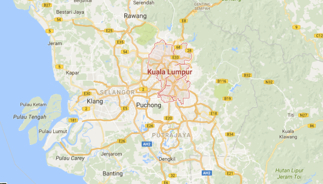
See the yellow squiggly lines? Those are highways. This shows that most of Greater KL is quite accessible by car and I’m grateful for that but apparently there are plans to build MORE highways to accommodate the increasing number of cars… That sucks, isn’t it high time we all realised that building more highways will not solve the congestion problem and is in the long term a very unsustainable and UGLY solution??? I’ll get back to that later. Next,
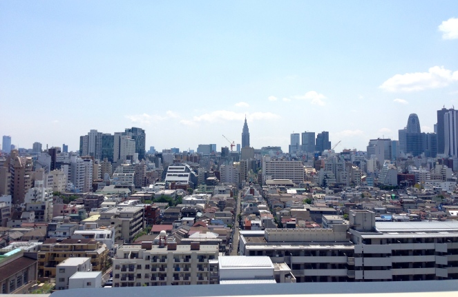
Tokyo: 2,187.66 km2
Greater Tokyo: 13,572 km2

HOLY SHOOTS lol what is considered Tokyo’s city area is the same size as Greater KL.
But then again, towards the West side of what is labelled as Tokyo (within the red boundary on the left) are mostly forests, mountains, and villages, even though they are still considered part of Tokyo prefecture.
And the vast area of Greater Tokyo (>13,000km2) is quite believable. Greater Tokyo is considered to include parts of its neighbouring prefectures like Yokohama and Kawasaki in Kanagawa prefecture as well as some parts of Chiba and Saitama prefecture. It is the largest and most populous metropolitan area in the world after all. Although it is so big, it’s easy to get around thanks to its comprehensive transportation network and helpful transportation apps providing real-time information.Tokyo, like most European cities and Singapore are one of the cities that did it right in the 1960s: instead of deploying a car-centric development plan they focused on investing in safe, extensive, and reliable mass transit.
And how does that compare to my current city?
Grenoble City: 18.13 km2
Grenoble-Alpes-Metropole: 541.17 km2
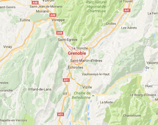
Teehee, that’s TINY!! So, the whole of Grenoble-Alpes-Metropole is the same size as my tiny town of Selayang back home (surface area of 549km2, north of Kuala Lumpur)↓ Now I know.
Source of this pic
In terms of transportation in Grenoble, the best part about it is that it is multi-modal, i.e. users have a wide variety of choices on how they want to get around. There’s a great tram and bus network, as well as a city-run bike rental service that I love called the Metrovelo. The city is planning to expand the total length of the bike lanes and I’m constantly seeing posters or plans pasted around the city notifying its citizens of plans to redesign the city to be more pedestrian friendly or measures like removing some parking lots for more efficient use of public space. I think I chose the right place to study urban planning ! ❤
Next, to compare my school commuting experiences:
KL Commute Distance: Around 17km
Commute Time: 30-40 minutes back in mid 2000s, but probably 50minutes – 1 hour in present day.
Mode: Private Car
KL, as with any developing countries and as you can see in the map above, is full of highways. I used this highway called Jalan Kuching from my house in suburban Selayang to get to my primary school / secondary school in KL. For ELEVEN YEARS. I was driven to and from school every day. And whoever drove me would have to come back to Selayang after dropping me, and then the other way round when picking me up.
So, the total distance driven in a month
= 17km x 2 x 2 x 5 days x 4 weeks = 1360km.
An efficient car can cover 100km with 8 litres of petrol so
13.6 x 8 = 108.8 litres of gasoline / week.
Using this calculator, I calculated that the car emits roughly 184g of CO2 / km, so
184g/km x 1360km = 250.62kg
Multiply by roughly 10 school months
250.62kg x 10 = 2506.2 kg
In conclusion, just the action of me going to school emits 2506.2 kg of CO2 annually. And according to Wikipedia, Malaysia’s CO2 emission per capita is 7500 kg, which means that I am definitely pulling my weight in contributing to the per capita CO2 emission with 1/3 of it caused by transportation only.
I’m not entirely bashing transport by private car, there are definitely perks to driving. For example, one can go anywhere at anytime they wish, being able to sing karaoke in the car and not be judged, road trips, transporting bulky things, transporting less active people like older people and the disabled, etc. Driving makes sense in some contexts.
And you don’t really need to be ON in your car, sometimes I only put on my shoes or comb my hair after I have reached my destination. In fact, I have a theory that people who commute by driving are more “emotionally ready” when they emerge from their “safe haven car” once they have reached their destination, because they didn’t need to interact with the other annoying passengers or depressed-looking passengers with their glassy stares in the train or bus before reaching work.
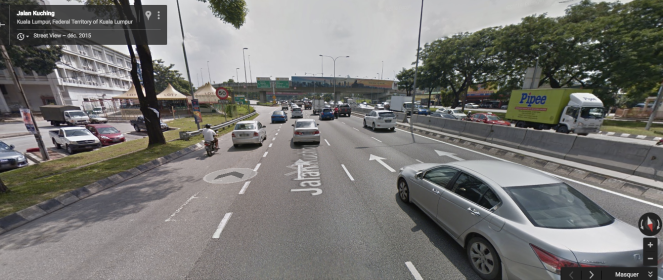
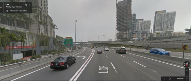
But driving also has its downsides outside of its adverse effects to the environment. Take a look at the pictures of the highways below, which I often take when I lived / now go back for holidays in KL (Beware, the highways are usually not this empty DUH, at peak hours they are jam-packed with cars and it’s horrible):
Federal Highway. Six lanes (per direction?) working at more than full capacity during rush hours. An ostrich was spotted running on this highway once.

This is also part of the Federal Highway, and you can see Mid Valley Megamall, one of the most popular malls in KL, on the left.

This is the LDP, going towards One Utama, another ultra-big mall in KL. It’s apparently the biggest mall in Malaysia and the sixth largest mall in the world.
What do you notice about these pictures? Besides the fact that they look unusually empty as opposed to how they look on a normal day, i.e. full of cars?
The answer is: There isn’t a single visible human face on these highways. Not unless you were stuck at a jam and you looked over to your sides to see someone else, who is also alone but ironically driving a four-seater car just to get to work.
Unlike walking, cycling, taking the bus or any kind of other transit system, when we drive, we are each enclosed in our little, movable personal space with none or minimal human interactions with the people around us. Yeah, interactions may occur sometimes, but they are usually in the form of occasional glares, giving the finger, road-raging back at someone who road-raged at you first, etc.
I’m exaggerating a little but the bottom line is, nobody gives a damn about the other cars on the road because of one psychological cause -the fact that they don’t look like humans. One interesting theory I’ve read is that people tend to get angry more easily when they’re driving because what you’re seeing is not people per say, but rather bulky metal boxes trying to cut into your lane or tailgating you rudely or just being there in the middle of the road, causing the traffic jam that ironically, YOU yourself are contributing to as well.
Another thing that I noticed since becoming an adult is that, all of my life of being chauffeured around (no, we didn’t have a real chauffeur, I was mostly driven around by family), all I knew of KL are the areas around my home, areas around the school, and areas where I’d hang out with friends, usually malls. Also, watching “Radiant City” the documentary mocking suburbia in the US which I highly recommend really struck a chord with me. One of the commentaries goes, “Kids need connection to civil, commercial, and social amenities, and they don’t get them in car-dependent societies.” In my specific upbringing, I didn’t get to experience anything that was beyond my world because I was in the car, probably sleeping, most of the time, whereas a teenager commuting to school using public transit on his own has to plan his own trip and manage his schedule, gets to see other people in the community who are different from him either from a different class or background or wtv, perhaps even connect his observations with the socio-economic policies of the community and be more practical or critical in his way of thinking. I guess this is what people call street smart, as opposed to book smart people like me who just knew how to get good results in school and make my parents proud. Book smart people are cool but the world needs more street smart people, and making our STREETS nice is definitely the right starting point.
Oh gosh, maybe I am car bashing after all. Please excuse moi, this is part of the identity crisis problem I was experiencing in summer in KL because while I hated driving, it was the only way I could get around. I was just there driving my Perodua Myvi like a stupid little hypocrite.
Anyway, let’s move on to Tokyo.
Tokyo Commute Distance: Around 17km
Commute Time: 50 minutes
Mode: Walking + Train
I had about the same amount of commuting distance from my home in the suburbs of Tokyo to Waseda University in Shinjuku, the centre of Tokyo. Although my commute time is longer than in KL, my CO2 footprint is a fraction of that in KL, AND I got to stay active because I walked 20 minutes one way, so 40 minutes in total every day.
CO2 produced on my commute in Tokyo, using a handy calculation sheet downloaded from this Tokyo Metropolitan City website (Japanese) =
16 km of rail travel produces 0.304 kg of CO2. So,
0.304g x 2 x 5 days a week x 4 weeks = 12.16kg / month
Ten months = 12.16kg x 10 = 121.16kg
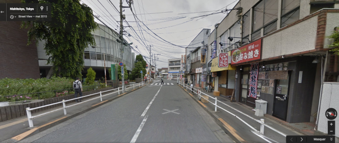
This is 5% of what I produce if I were to drive in KL. Here is a pic of one of the roads I used to walk (12 minutes) from my dorm to the closest train station, Tanashi.
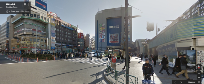
After alighting at Takadanobaba (20 minutes on the express train from Tanashi), I head out of the station to a nice, bustling, student town station square in front of Big Box the shopping mall which houses Vie De France where I used to buy melon-pans to binge eat on every spring. Vie De France means Life of France, and now that I am literally living a life in France I don’t see myself eating any melon-pans. How strange.
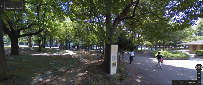
The last leg of my 10-minute walk from the Takadanobaba station to my uni (Nishi Waseda campus) consists of a stroll through Toyama Park, which looks like this ↓ in the summer but full of blooming cheery blossoms in the spring. As you can see in these three pics, the whole urban environment is designed to give priority to the pedestrian / cyclist.
I guess I can praise the walkability of Tokyo and criticise KL all day long, but one important thing is that we also need to remember is that not everything that works in Tokyo will work in KL. E.g., although Japan has blistering summers, weather for most parts of the year is temperate and conducive for walking. Plus the low crime rate and relatively small income gap in Japan are also HUGE factors contributing to a safe and pleasant walking environment.
One bad thing about this commute though, was that let’s say if I left something at home, I would have to spend 2 frigging hours just to go home and come back to school again. While Tokyo city is as dense as it gets, land prices are just too high in the city centre for mediocre people like me so like most capital cities with a strong centre, people have to live far away from their workplaces and suffer the long commutes. This is why it’s completely acceptable to sleep on the trains in Japan, and the person nodding off next to you had most probably woken up at 4:30am in the morning just to travel 2 hours to school / work.
Next up, La France.
Grenoble Commute Distance: About 4~5km
Commute Time: 20 minutes
Mode: Walking + Biking
So I spent a semester from Jan-May earlier this year learning French at CUEF, Stendhal University in Grenoble. Like I said above, Grenoble is just bursting with transportation options because of its modest size and governance by a pro-environment political party, Les Verts, or The Greens.
Here is 5 minutes in to my commute to school by bike. SO GREEN. And full of insects in the summer. Exclusive bike / pedestrian paths on the right of the pic.

Then I cycle uphill for 20 seconds onto a flyover. Exclusive bike / pedestrian lane still continues here, albeit a little narrower.

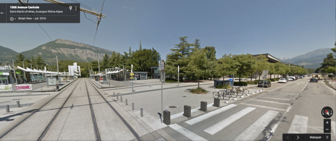
Then I arrive on campus after 15-20 minutes of pedalling. This is the tram stop closest to my school. MOUNTAINS! Beautiful mountains. And beautiful SUPER PLANNED, efficient looking urban environment. It looks a bit bare here in the pic but it’s usually nicer with local and international students getting their baguette sandwiches and frolicking on the benches / patches of grass on their 2-hour lunch breaks.
Oh, and you know what? The CO2 emission calculation is easy for Grenoble, its ZERO. Nothing. I’m not releasing anything into the wild except my own calories, which partly explains my slimmer figure since I came to France. And another thing about cycling and walking is that I control my own speed. When I’m running late I just run or pedal faster and STILL get there in time, with just slightly redder cheeks. And probably more calories burnt in the process.
To sum it up!:
| City |
Size (km2) |
Commute Distance |
Commute Time |
Commute Mode |
CO2 output |
| KL |
243 (2243) |
17km |
30-40 minutes |
Private Car |
2500 kg / year |
| Tokyo |
2187 (13572) |
17km |
50 minutes |
Walk + Train |
121.6kg / year |
| Grenoble |
18 (541) |
4.5km |
20 minutes |
Walk + Bike |
0 |
In conclusion, (TL;DR):
I’m just one of those people who grew up in an urban sprawl environment who went overseas and discovered that there are people who have very different and better lifestyles that are less dependent on cars.
So much of lives and our productivity are affected by the decisions of our politicians or policy makers from one or two generations ago. Now that they’re developing the MRT system in KL I’m quite optimistic that maybe we’re heading in the right direction, hopefully!!
Speaking of urban planning, my course starts tomorrow!! Très nerveuse!